Part A, Step 2 of the 2021 ACE Calculation Method
Crossing Classification and Special Treatment Assumptions
Part A, Step 2 of the 2021 Abandonment Cost Estimate (ACE) Calculation Method
- classifies the number of crossings by crossing type along the lengths of operatingFootnote 1 and decommissioned pipelines in a company’s pipeline system; and
- determines the assumed number of crossings for which special treatment (e.g., fill) will be applied.
Select a tab below to learn more about each.
Classify pipeline crossings by ACE crossing category
The 2021 ACE Calculation Method has four crossing categories: Water Crossings, Road Crossings - Paved, Road Crossings - Unpaved, and Railway Crossings. A description of each category for the purposes of the 2021 ACE Calculation Method is provided in the table.
As shown in the table, a selection of transportation attributes found in the three Natural Resources Canada hydrographic, road and railway geospatial datasets are assigned to each 2021 ACE Calculation Method crossing category.
| ACE crossing category | Description | Dataset and attributes used to delineate the category |
|---|---|---|
| Water Crossings | Crossings of watercourses and waterbodies | CanVec Series – Hydrographic Features Dataset
|
| Road Crossings – Paved | Crossings of paved roads found both in urban and rural areas | National Road Network - NRN - GeoBase Series
|
| Road Crossings – Unpaved | Crossings of unpaved roads found both in urban and rural areas | National Road Network - NRN - GeoBase Series
|
| Railway Crossings | Crossings of railway tracks | National Railway Network Dataset
|
Calculation methodology and finding this calculation in an ACE
This step in the 2021 ACE Calculation Method determines the total number of crossings by crossing category and pipeline diameter categoryFootnote 2 intersected by a company’s operating and decommissioned pipelines using the Natural Resource Canada hydrographic, road and railway datasets.
The link below provides a detailed explanation of the methodology used, including some noted limitations.
-
Crossing count methodology
After ACEs were issued during the 2021 ACE/SAM-COM Review, the Commission noted limitations with the current crossing count methodologyFootnote 3. Specifically, it said the crossing counts being generated were not necessarily reflective of the actual number of crossings. Since the 2021 ACE/SAM-COM Review, the CER has noted one further limitation with the crossing count methodology being used. These limitations may result in the crossing counts in a company’s ACE being either under or over-estimated. It is expected that the 2021 ACE Calculation Method will continue to be revised and improved in future reviews.
For transparency, the noted limitations are explained in detail in the links below. Depending on the location of a particular pipeline, either one or both of the limitations may apply.
Overlap of provincial hydrographic datasets
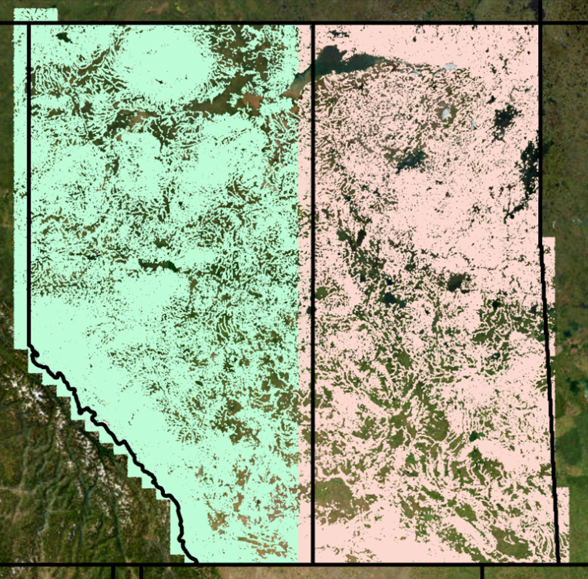
The provincial hydrographic datasets overlap the adjoining provincial/territorial datasets at some locations which results in the 2021 ACE Calculation Method double-counting water crossings along pipelines which traverse areas of data overlap. When it occurs, that overlap is between 0 and 30 kilometres wide and occurs on either side of the provincial and territorial boundaries.
As an example, in the image below taken from the CER’s geographic information system, the extent of the Alberta (green) and Saskatchewan (pink) provincial hydrographic datasets are shown. The areas in green and pink which extend outside of those provinces’ boundaries are where double-counting of water crossings occurs in the 2021 ACE Calculation Method. While not shown in the image, as it is hidden beneath the Saskatchewan data layer, the Alberta dataset also has an area of overlap which extends eastward into Saskatchewan along the Alberta-Saskatchewan border.
Intersection counts
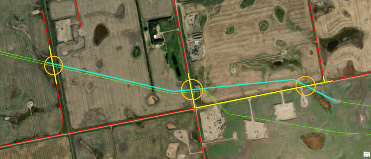
To count the number of crossings a pipeline makes with water, roads or railways, the CER’s geographic information system overlays a company’s pipeline data, which has been segmented by land cover type, with hydrographic, road and railway data found within a 100 metre radius area of the pipeline system.
First, the geographic information system delineates a company’s pipeline data by land cover by overlaying the company’s pipeline data with the land cover dataset. Each of the resulting smaller pipeline segments is then used to determine the number of intersections or crossings the segment makes with data in the hydrographic, road, and railway datasets.
For each pipeline segment that intersects with a certain crossing type (hydrographic, paved road, unpaved road, or railway), the 2021 ACE Calculation Method applies a crossing count of one to the pipeline segment, regardless of the number of intersections the pipeline segment makes with that crossing type segment over its length. This is caused by the process calculating how many times a particular pipeline segment intersects the provincial crossing type layer, rather than each crossing type segment. There may be two or three individual intersections of a pipeline segment with a particular crossing type, but only one crossing is counted. This may result in watercourse, paved road, unpaved road, and railway crossing counts currently being underestimated.
An example of this issue is shown in an image from the CER’s geographic information system below. A company’s pipeline system (shown in green) has been categorized by land cover type, and at this location, the pipeline has been segmented and assigned a land cover type of “cultivated” (shown in blue). Road data within 100 metres of the pipeline segment (shown in yellow) has then been overlaid in the geographic information system to determine the number of intersections. In this case, the image shows that there are three unpaved road crossings along the pipeline segment (the intersections of the pipeline with the unpaved roads are circled in orange); however, the 2021 ACE Calculation Method counts one unpaved road crossing for the segment.
Determine assumed number of crossings with special treatment
Once the number of crossings along the company’s operating and decommissioned pipelines are categorized by crossing category and pipeline diameterFootnote 2, the 2021 ACE Calculation Method applies Base Case 2021 abandonment method assumptions to each to calculate the total number of crossings assumed to have special treatment applied at the time of abandonment.
The Base Case 2021 abandonment method assumptions for crossings are shown in the table below. These abandonment method assumptions do not determine the methods that will be used to abandon specific pipeline crossings. Rather, these assumptions were established by the Commission to calculate ACEs and broadly reflect the probability of the special treatment being applied at different crossing types at all CER-regulated pipelines across Canada.
| ACE land use category | ACE pipeline diameter category | |||
|---|---|---|---|---|
| Very small | Small | Medium | Large | |
| Water Crossings | 100% A | 95% A – 5% A+ | 95% A – 5% A+ | 95% A – 5% A+ |
| Road Crossings - Paved | 100% A | 100% A | 100% A+ | 100% A+ |
| Road Crossings - Unpaved | 100% A | 100% A | 50% A – 50% A+ | 50% A – 50% A+ |
| Railway Crossings | 100% A | 100% A+ | 100% A+ | 100% A+ |
| Legend: A = abandoned in place; A+ = abandoned in place with special treatment | ||||
Calculation methodology and finding this calculation in an ACE
The number of crossings assumed to be abandoned in place with special treatment are reported in the crossing category tables shown in Part A, Step 2 of an ACE by pipeline diameter. Separate tables are provided in this section of the ACE for each crossing category intersected by a company’s operating and decommissioned pipelines.
The applicable Base Case 2021 abandonment method assumptions for crossings are shown in the second and third column of each table for each crossing and pipeline diameter category. Those abandonment method assumptions are applied to the crossing counts shown in the first column of the tables to determine the number of crossings assumed to be abandoned in place with special treatment. The results of this calculation are reported in the fourth column of the tables.
View the example ACE to see where this information is shown in an ACE.
The number of crossings assumed to have special treatment applied by pipeline diameter are used to calculate costs for the Special Treatment cost category in Part A, Step 3.
- Date modified: