Part A, Step 1 of the 2021 Abandonment Cost Estimate Calculation Method
Land Use Categorization and Pipeline Abandonment Method Assumptions
Part A, Step 1 of the 2021 Abandonment Cost Estimate (ACE) Calculation Method:
- categorizes a company’s operatingFootnote 1 and decommissioned pipelines by ACE land use category; and
- determines the assumed lengths of pipeline to be abandoned in place and removed.
Select a tab below to learn more about each.
Categorize pipelines by ACE land use category
The 2021 ACE Calculation Method has five land use categories: Agricultural Cropland, Grasslands and Shrublands, Forested Lands, Wetlands-Water, and Existing Developed Lands. A description of each land use category is provided in the table below.
As shown in the table, each land cover attribute in the Altas of Canada Land Cover Dataset is assigned to an ACE land use category. The definitions Natural Resource Canada uses for each land cover attribute in the dataset can be found using an interactive map on Natural Resources Canada’s website. The 2021 ACE Calculation Method uses all land cover attributes in the Altas of Canada Land Cover Dataset, except for the ‘snow and ice’ attribute.
| ACE land use category | Description | Atlas of Canada Land Cover Dataset land cover attributes used to delineate the category |
|---|---|---|
| Agricultural Cropland | Agricultural lands used for the production of annual crops, perennial grasses for grazing, and woody crops such as orchards and vineyards |
|
| Grasslands and Shrublands | Encompasses native prairie, agricultural pasture lands, shrublands, and barren areas with limited vegetation |
|
| Forested Lands | Includes both publicly and privately owned forested lands and encompasses land practices such as timber harvesting and agriculture (e.g., maple stands) |
|
| Wetlands – Water | Wetlands including marshes, swamps, and bogs, and areas covered by water |
|
| Existing Developed Lands | Developed areas such as cities and towns |
|
Calculation methodology and finding this calculation in an ACE
Using the CER’s geographic information system, the 2021 ACE Calculation Method overlays the geospatial pipeline data provided by a company with the Altas of Canada Land Cover Dataset to determine the lengths of pipeline in each ACE land use category.
The results of the land use classification are shown in Part A, Step 1 of an ACE. Separate land use tables are provided in this section of the ACE for each land use category intersected by the operating and decommissioned pipelines in a company’s pipeline system. The third column in each land use table reports the total actual lengths (in kilometres) of operating and decommissioned pipelines in the land use category, by commodity type and pipeline diameter category.
View the example ACE to see where this information is shown in an ACE.
The actual pipeline lengths reported in this section of the ACE are used to calculate some of the pipeline abandonment activity costs in Part A, Step 3 and Part A, Step 6 of an ACE. Specifically, these include the Land Access, Pipeline Purging and Clean-up, and Remediation cost categories in Part A, Step 3 of an ACE.
Data Adjustments
While developing the 2021 ACE Calculation Method, the CER noted two issues with Altas of Canada Land Cover dataset which required adjustments to ready the data for use by the 2021 ACE Calculation Method. These issues and the corresponding adjustments made are described in detail below.
-
“Urban and Built Up” attribute over-representation in rural area
In rural areas, it was found that many ‘pixels’ in the dataset (30 metre by 30 metre areas, as per the resolution of the dataset) which had roads or portions of roads within them were assigned the “urban and built up” attribute, likely due to the high reflectivity of those surfaces (i.e., similar reflectivity to buildings found in urban areas). However, as those pixels in rural areas are generally surrounded by pixels assigned non-urban land cover attributes (e.g., cropland, grassland, mixed forest) and the roads within the pixels assigned the “urban and built up” attribute have widths typically much less than the width of the 30 m pixel, there appeared to be an over-representation of pixels assigned the “urban and built up” attribute in the dataset, particularly in rural areas. As the abandonment method assumptions for the “Existing Developed Lands” land use category has a higher pipeline removal percentage than the other non-urban land use categories in the 2021 ACE Calculation Method, this over-representation would result in increased abandonment costs in an ACE.
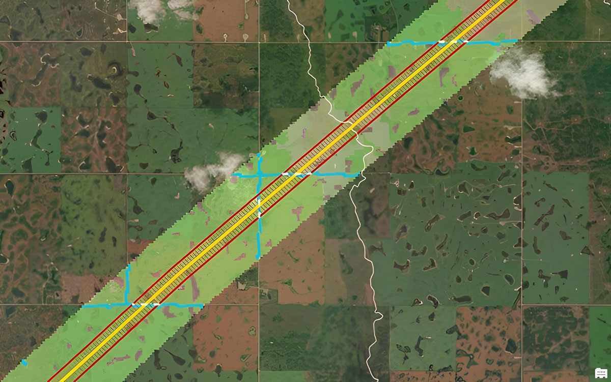
This issue is explained visually in the image below. Land cover classification from the Altas of Canada Land Cover dataset within a 500 metre radius area centered on an example pipeline (yellow) is shown. The land cover in this area is predominantly cropland (light green), interspersed with smaller areas assigned to the “urban and built up” attribute (blue) and non-urban attributes (e.g., forest, shrubland, grassland and water shown in shades of brown, grey and dark green). Road data from the National Road Network - NRN - GeoBase Series dataset within a 100 metre radius buffer of the pipeline has been overlaid on the land cover data in the image (buffer area is shown in red; the white dashed lines depicts the roads found within that data). The road data shows that the land cover areas assigned to the ”urban and built up” attribute (blue) in the land cover dataset are roads and not urban developed areas such as cities and towns as described for the “Existing Developed Lands” land use category.
Before correction
To correct the issue, the 2021 ACE Calculation Method program does the following:
- The pipeline data is overlaid with the land cover and road data (National Road Network - NRN - GeoBase Series) in the geographic information system.
- At each intersection of the pipeline system with a road in the road dataset, the program generates a 250 metre buffer area around the road segment and calculates the total percentage of each landcover type within that buffer area.
- If the “urban and built up” attribute value is not the predominant land use type in the 250 metre buffer area of the road intersection, then the program re-assigns the “urban and built up” area within the buffer area to the land cover value that was found to be most predominant. If the “urban and built up” value is the predominant land use type in the buffer area, then the land cover value remains unchanged.
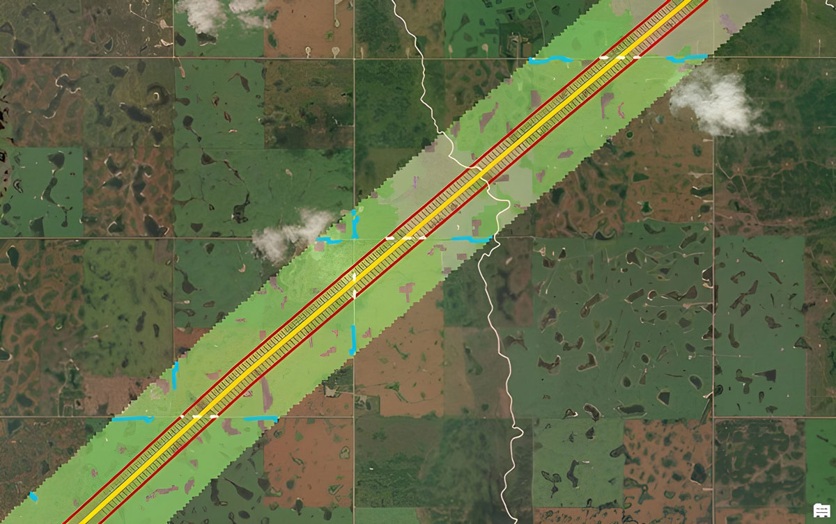
As shown in the image below, when the correction is applied to the example, the pixels that were previously assigned with the “urban and built up” attribute within the road crossing buffer area have been re-assigned to attributes which describe the surrounding land cover.
After correction
-
“Snow and Ice” attribute assigned in areas where there is no permanent snow and ice
The CER found a few locations along some companies’ pipeline systems where the attribute assigned to certain land cover pixels in the Altas of Canada Land Cover Dataset was “snow and ice”. CER-regulated pipelines are not found in areas with permanent snow and ice, and this attribute was likely assigned by Natural Resources Canada at these locations in the dataset as a result of the landscape features having high reflectivity.
To correct the issue, the CER examined the land cover attributes assigned to the surrounding pixels at those locations and found that they were better described by the “water” attribute. As a result, when calculating a company’s ACE, the 2021 ACE Calculation Method searches for any pixels in the land cover dataset assigned the attribute “snow and ice”, and re-assigns them to the “water” attribute.
Determine assumed lengths of pipeline to be abandoned in place and removed
Once a company’s operating and decommissioned pipelines are categorized by land use and pipeline diameterFootnote 2, the 2021 ACE Calculation Method applies Base Case 2021 abandonment method assumptions to each to calculate:
- the total length of pipeline assumed to be abandoned in place; and
- the total length of pipeline to be removed.
The Base Case 2021 abandonment method assumptions are shown in the table below. These abandonment method assumptions do not determine the methods that will be used to abandon specific pipelines. Rather, these assumptions were established by the Commission to calculate ACEs and broadly reflect the probability of the different abandonment methods being applied within different land uses for all CER-regulated pipelines across Canada.
| ACE land use category | ACE pipeline diameter category | |||
|---|---|---|---|---|
| Very small | Small | Medium | Large | |
| Agricultural Cropland | 95% A – 5% R | 95% A – 5% R | 80% A – 20% R | 80% A – 20% R |
| Grasslands and Shrublands | 95% A – 5% R | 95% A – 5% R | 90% A – 10% R | 90% A – 10% R |
| Forested Lands | 95% A – 5% R | 95% A – 5% R | 95% A – 5% R | 95% A – 5% R |
| Wetlands – Water | 95% A – 5% R | 95% A – 5% R | 95% A – 5% R | 95% A – 5% R |
| Existing Developed Lands | 80% A – 20% R | 80% A – 20% R | 80% A – 20% R | 80% A – 20% R |
| Legend: A = abandoned in place; R = removed | ||||
Calculation methodology and finding this calculation in an ACE
The total pipeline lengths assumed to be abandoned in place and removed (in kilometres) are reported in the land use category tables shown in Part A, Step 1 of an ACE by pipeline diameter and commodity type. Separate tables are provided in this section of the ACE for each land use category intersected by a company’s operating and decommissioned pipelines.
The applicable Base Case 2021 abandonment method assumptions for pipelines are shown in the fourth column of each table in Part A, Step 1 of an ACE. Those abandonment method assumptions are then applied to the total actual pipeline lengths shown in the third column of the tables to calculate the total pipeline lengths assumed to be abandoned in place and removed, which are reported in the fifth and sixth columns of the tables respectively.
View the example ACE to see where these calculations are reported in an ACE.
The total pipeline lengths assumed to be abandoned in place and removed are used to calculate some of the pipeline abandonment activity costs in Part A, Step 3 and Part A, Step 6 of an ACE. Specifically, the total pipeline length assumed to be abandoned in place is used to calculate the Pipeline Abandonment in Place and Reclamation and Restoration cost categories in Part A, Step 3 of an ACE, and the Provision for Abandoned Pipelines in Part A, Step 6. The total pipeline lengths assumed to be removed are used to calculate the Pipeline Removal and Reclamation and Restoration cost categories in Part A, Step 3.
- Date modified: